LAGO   Consulting   &   Services LLC
    • Home
    • About Us
      • The Company
      • Leadership
      • Certifications
    • Services
      • Modeling Services
      • Consulting Services
      • Software Development >
        • Fill Sinks Plus
        • HEC-RAS to MIKE11
        • SWMM5 to Shp
        • Lago Toolbox
    • Projects
    • FAQ/Contact
    • LAGO-LG2 JV
  • MENU

  Immokalee Stormwater Master Plan Update   


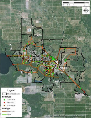
​Client: Collier County (sub-consultant to Robau & Associates)​
Year: 2016-2018
​

About: 
The first objective of this project was to conduct a comprehensive update of the XP-SWMM model originally developed in 2004. The updated model was then used to evaluate nine (9) proposed projects and subprojects to improve the stormwater management system. Design storm simulations for the 10- and 25-year/3-day storm events were utilized. Water quality improvements from the proposed ponds were also evaluated using the Harvey-Harper Method.
Applied Skills:
  • H&H Modeling: Data Processing, Conceptualization & Setup
  • Design storm simulations
  • Level of Service
  • Scenario Evaluation
Consulting Areas:
  • Surface water Management
  • ​Water quality studies
Software Applied:
  • XP-SWMM
  • SWMM5 to SHP
  • ArcMap
  • ArcHydro
  • Fill Sinks Plus
Specifics:
The model update included:
  • New sub-basin and flow paths delineation based on new topography data and by using ArcHydro tools, as well as aerial imagery and permit information.
  • New landuse and soil data used to determine the curve number (CN) for infiltration determination.
  • New runoff parameters (area, % impervious, width, and slope).
  • New conduit parameters based on the County geodatabase, permit information, other models for the area, and field visits.
Picture
Picture
Picture
​Outcome:
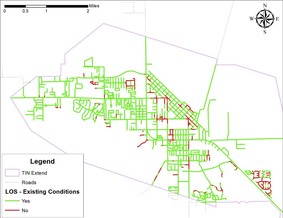
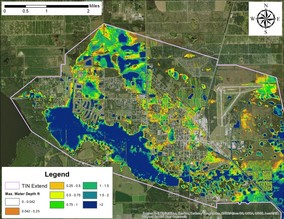
The updated model was used to evaluate the stormwater management system in Immokalee and to estimate the potential effects of the proposed projects to reduce the extent and duration of flooding in the project area.  Flood inundation maps and road Level of Service (LOS) compliance maps were produced for this evaluation. The proposed designs were adjusted according to the model results in order to optimize performance.
​<  Previous Project
Next Project  >
  • Home
  • About Us
    • The Company
    • Leadership
    • Certifications
  • Services
    • Modeling Services
    • Consulting Services
    • Software Development >
      • Fill Sinks Plus
      • HEC-RAS to MIKE11
      • SWMM5 to Shp
      • Lago Toolbox
  • Projects
  • FAQ/Contact
  • LAGO-LG2 JV
Modeling Services
Picture

- Data mining & Processing
- Conceptualization & Setup
- Sensitivity Tests
- Model Calibration
- Model Telescoping
- Design Storm Simulations
- Scenario Evaluations
​- Post-Processing of results
- Peer review
- Model QA/QC
- Mass balance checks
- Fixing numerical instabilities
- Calibration/validation checks
​- Reservoir Storage Modeling
- GIS data mgmt. and tools

Consulting Areas
Picture

- Natural resources planning
- Stormwater management
- Groundwater management
- Surface water structure design
- Water supply planning
- Species and sediment transport
- Salt water intrusion
- Floodplain delineation & management
- Floodway Encroachment Analysis
​- Urban and coastal flooding
- Water quality studies
- Wetland conservation and restoration
- Wellhead protection area delineation
- Landscape ecology
- Water regulations permitting

Featured Software
Picture

MIKE 11
MIKE SHE
MIKE21
ECOLab
MODFLOW
GWV (Vistas)
MODHMS
​GIS-ArcMap

HEC-RAS
​HEC-HMS
EPA-SWMM
​XP-SWMM
ICPR
​RiverFlow2D
WASP
HSPF

Software Development
Picture

Spreadsheet modeling
File format converters
Pre- & post-processing tools
A la carte software (C#, Python, etc)


Employee Login   ​
         About    |    Terms  and Conditions    |    Privacy Policy    |    Certifications    | ​   Tools    |    Contact us     
Picture
4237 Henderson Blvd #201, Tampa FL 33629.   |   P.O. Box 10481, Tampa, FL, 33679   |   813-774-5559
www.lago-consulting.com & Lago Consulting & Services LLC.    © 2023  All Rights Reserved