
I-75 Widening - H/H Model
|
Client: HDR Inc. (sub-consultant to ADA Engineering Inc.)
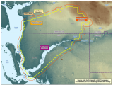
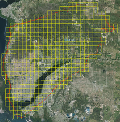
Year: 2013 About: Regional Watershed Modeling to support the Stormwater Management Design calculations for the project of widening a portion of the Interstate I-75. |
|
Specifics:
The regional Watershed Model with MIKE SHE / MIKE 11 integrated catchment modeling of groundwater and surface water was used to support the Storm-water Management Design calculations for the project of widening 8.102 miles of Interstate I-75. LAGO improved the SHE file with new rainfall and reference ET input data, created shape files with the NEXRAD grid cells in the model domain area to be used in the station based option for input rainfall and reference ET data. LAGO used software tools to create a total of 446 dfs0 files with NEXRAD rainfall time series as provided by the SFWMD for the period of 2010 through May 2013 and to create a total of 416 dfs0 files with reference ET time series as provided by the USGS for the period from year 1995 through 2011. More recent values for years 2012 and 2013 were adopted from Julian averaged values. |
|
|
Applied Skills:
Outcome: The MIKE SHE model was updated by incorporating new meteorological data. |


