LAGO   Consulting   &   Services LLC
    • Home
    • About Us
      • The Company
      • Leadership
      • Certifications
    • Services
      • Modeling Services
      • Consulting Services
      • Software Development >
        • Fill Sinks Plus
        • HEC-RAS to MIKE11
        • SWMM5 to Shp
        • Lago Toolbox
    • Projects
    • FAQ/Contact
    • LAGO-LG2 JV
  • MENU

Flood Modeling Evaluation

Picture
 
​Client: City of Olathe (sub-consultant to WRCS)

​Year: 2020
​​
About: 
The City of Olathe was concerned about the existing storm water facilities regarding their capacity to hold the 100-year storm event runoff inside the existing ponds without causing flooding in the future, if the area is fully developed. LAGO provided modeling support to Mr. Rick Van Bruggen, P.E., CFM, D.WRE at Water Resources Consulting Services, Inc. (WRCS).
​Applied Skills:
  • Model setup and post-processing
  • Flood mapping​
​
Consulting Areas:
  • Stormwater management
  • Flooding assessment​​
​​​
​Software Applied:
  • HydroCAD
  • ICPR
  • ArcMap
​Specifics:
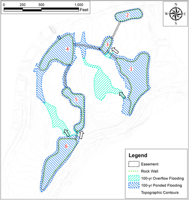
LAGO reviewed and improved the existing HydroCAD model to estimate pond peak levels from 1-, 10-, and 100-year design storms. A similar model was also created in ICPR software to obtain those estimations by using a more dynamic approach.   

​Outcome:
DEM processing showed that the ponds were constructed with a smaller capacity than designed. Thus, the dirt volume to bring the ponds to the design capacity was calculated below and above normal pool elevations.
LAGO also processed the model results to obtain flood maps and to quantify the flooded areas.  In addition, the volume of dirt necessary to fill the site to an elevation of 2 feet above the BFE was estimated. 
Picture
<  Previous Project
Next Project >
  • Home
  • About Us
    • The Company
    • Leadership
    • Certifications
  • Services
    • Modeling Services
    • Consulting Services
    • Software Development >
      • Fill Sinks Plus
      • HEC-RAS to MIKE11
      • SWMM5 to Shp
      • Lago Toolbox
  • Projects
  • FAQ/Contact
  • LAGO-LG2 JV
Modeling Services
Picture

- Data mining & Processing
- Conceptualization & Setup
- Sensitivity Tests
- Model Calibration
- Model Telescoping
- Design Storm Simulations
- Scenario Evaluations
​- Post-Processing of results
- Peer review
- Model QA/QC
- Mass balance checks
- Fixing numerical instabilities
- Calibration/validation checks
​- Reservoir Storage Modeling
- GIS data mgmt. and tools

Consulting Areas
Picture

- Natural resources planning
- Stormwater management
- Groundwater management
- Surface water structure design
- Water supply planning
- Species and sediment transport
- Salt water intrusion
- Floodplain delineation & management
- Floodway Encroachment Analysis
​- Urban and coastal flooding
- Water quality studies
- Wetland conservation and restoration
- Wellhead protection area delineation
- Landscape ecology
- Water regulations permitting

Featured Software
Picture

MIKE 11
MIKE SHE
MIKE21
ECOLab
MODFLOW
GWV (Vistas)
MODHMS
​GIS-ArcMap

HEC-RAS
​HEC-HMS
EPA-SWMM
​XP-SWMM
ICPR
​RiverFlow2D
WASP
HSPF

Software Development
Picture

Spreadsheet modeling
File format converters
Pre- & post-processing tools
A la carte software (C#, Python, etc)


Employee Login   ​
         About    |    Terms  and Conditions    |    Privacy Policy    |    Certifications    | ​   Tools    |    Contact us     
Picture
4237 Henderson Blvd #201, Tampa FL 33629.   |   P.O. Box 10481, Tampa, FL, 33679   |   813-774-5559
www.lago-consulting.com & Lago Consulting & Services LLC.    © 2023  All Rights Reserved