LAGO   Consulting   &   Services LLC
    • Home
    • About Us
      • The Company
      • Leadership
      • Certifications
    • Services
      • Modeling Services
      • Consulting Services
      • Software Development >
        • Fill Sinks Plus
        • HEC-RAS to MIKE11
        • SWMM5 to Shp
        • Lago Toolbox
    • Projects
    • FAQ/Contact
    • LAGO-LG2 JV
  • MENU

Smooth dfs2 Files

Purpose
    
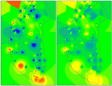
​This tool allows the smoothing of the maps in a dfs2 file by performing spatial averages around each grid cell according to a specified search radius. Optionally, the tool allows also capping or gap filling operations.

Usage
    The user must specify the dfs2 file name and the search radius in grid cell size units. A radius equal to one means, for example, that the four nearest neighbor values will be considered in the average (i.e., maximum count = 5). 
    The user can also specify whether they would like to use unweighted or weighted averages. If the user wants to use weighted averages they must choose between a weight of 1/r (i.e., 1 divided by the distance from central cell) or 1 / r ^2. By using weighted averages, the user can also specify a value for the radius assumed for the central cell during smoothing.
    Optionally, the user can perform a gap filling operation by checking the box “Only modify cells with No Data values”. In this case, the cell with values will not be altered, and only the average around empty grid cells will be used to replace the “No Data” values.
    Another available option is to cap the values above and below specified values, percentiles, or a factor of the median value. In the case of specifying percentiles or factor of the median values, a dfs2 file with a selection can by specified in order to find those values by using only the selected cells.
    Clicking the “Smooth dfs2 file” button produces a new dfs2 file with the same number of items and time steps, but with smoothed values.  
    The free version allows the user to save up to the first 50x50 elements of the grid.

Pre-requisites
    It requires MIKE ZERO 2012, 2014, 2016, 2017 or 2019 to be installed, but the DHI license is not necessary.

Example of use
    The printscreen below shows the tool windows, as example, while processing a map of hydraulic conductivities. There are also included printscreens of the map before and after executing the tool. In this case, the output map displayed smoother transitions at sharp edges and bull eyes.
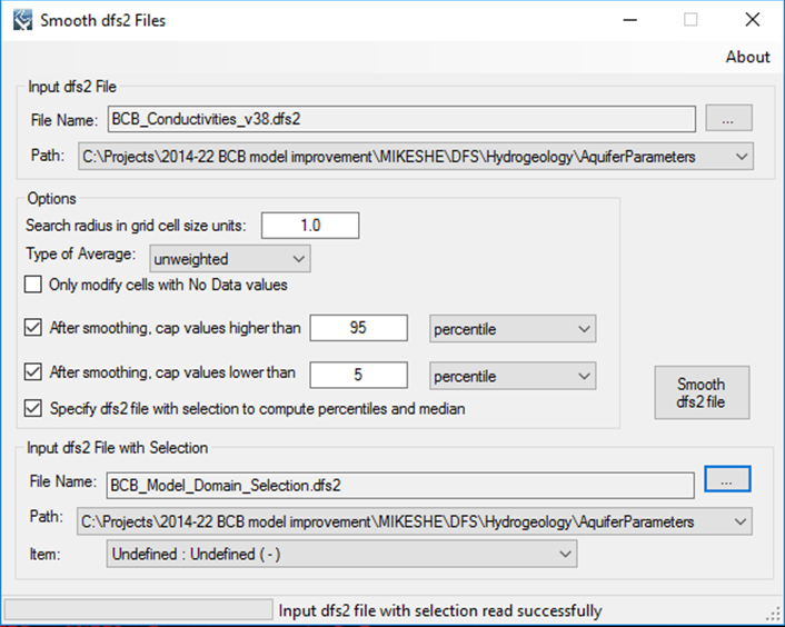
​
Picture
Picture
​Registration
    ​In order to have full functionality of this tool, the user needs to complete the registration process by following these steps:
​Go to the right-top corner in this tool, click on the “About” button, and copy the Mac address shown there.
Picture
In the tool’s webpage, use the box above the "Add to Cart" button to enter the Mac address. Then, click on the "Add to Cart" button right below to enter your payment information.
​After these steps, the authorization code will be sent to the email that you provided during the PayPal payment process.

Support
Users can report bugs and send comments by email to [email protected].  
 
Created by Lago Consulting & Services LLC. © 2015. Last updated on 05/28/2019
​
Questions?
Contact Us

Lago consulting and services understands the customer's risks when downloading  or installing software from internet. The integrity of the software we offer here as well as the legitimacy of our company are ensured by our code signing certificate.
Free version available in the Toolbox or here
​
for an independent download.
Picture
If you are interested on purchasing this tool contact us for more information. ​
Picture
  • Home
  • About Us
    • The Company
    • Leadership
    • Certifications
  • Services
    • Modeling Services
    • Consulting Services
    • Software Development >
      • Fill Sinks Plus
      • HEC-RAS to MIKE11
      • SWMM5 to Shp
      • Lago Toolbox
  • Projects
  • FAQ/Contact
  • LAGO-LG2 JV
Modeling Services
Picture

- Data mining & Processing
- Conceptualization & Setup
- Sensitivity Tests
- Model Calibration
- Model Telescoping
- Design Storm Simulations
- Scenario Evaluations
​- Post-Processing of results
- Peer review
- Model QA/QC
- Mass balance checks
- Fixing numerical instabilities
- Calibration/validation checks
​- Reservoir Storage Modeling
- GIS data mgmt. and tools

Consulting Areas
Picture

- Natural resources planning
- Stormwater management
- Groundwater management
- Surface water structure design
- Water supply planning
- Species and sediment transport
- Salt water intrusion
- Floodplain delineation & management
- Floodway Encroachment Analysis
​- Urban and coastal flooding
- Water quality studies
- Wetland conservation and restoration
- Wellhead protection area delineation
- Landscape ecology
- Water regulations permitting

Featured Software
Picture

MIKE 11
MIKE SHE
MIKE21
ECOLab
MODFLOW
GWV (Vistas)
MODHMS
​GIS-ArcMap

HEC-RAS
​HEC-HMS
EPA-SWMM
​XP-SWMM
ICPR
​RiverFlow2D
WASP
HSPF

Software Development
Picture

Spreadsheet modeling
File format converters
Pre- & post-processing tools
A la carte software (C#, Python, etc)


Employee Login   ​
         About    |    Terms  and Conditions    |    Privacy Policy    |    Certifications    | ​   Tools    |    Contact us     
Picture
4921 S West Shore Tampa FL 33611, P.O. Box 10481, Tampa, FL 33679.  813-774-5559
www.lago-consulting.com & Lago Consulting & Services LLC.    © 2023  All Rights Reserved