LAGO   Consulting   &   Services LLC
    • Home
    • About Us
      • The Company
      • Leadership
      • Certifications
    • Services
      • Modeling Services
      • Consulting Services
      • Software Development >
        • Fill Sinks Plus
        • HEC-RAS to MIKE11
        • SWMM5 to Shp
        • Lago Toolbox
    • Projects
    • FAQ/Contact
    • LAGO-LG2 JV
  • MENU

Shape plus dfs23 to dfs0

Purpose
    This tool allows the conversion of a point shape file and a time-varying dfs2/dfs3 file into dfs0 file(s). Some highlights are:
  • Shape fields or columns can be used to specify the station names, dfs0 file names, and z-layer index.
  • Spatial interpolation by using nearest neighbor or bilinear methods.

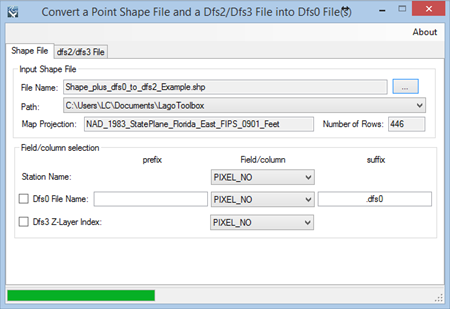
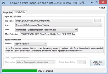
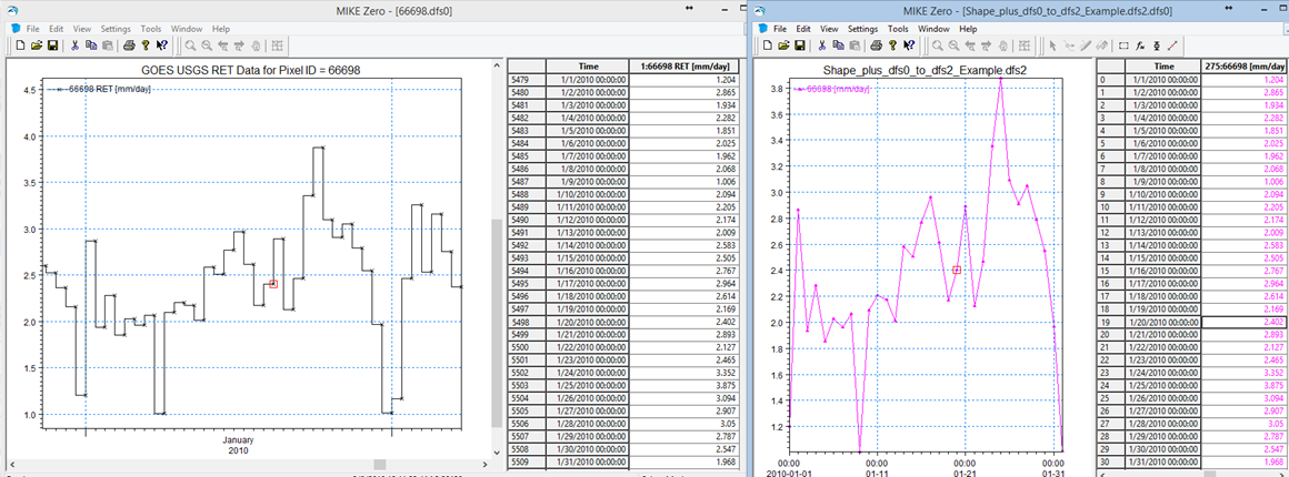
Usage
    The user must specify a point shape file with the station locations as input and choose a field for the station name. Optionally, shape file fields can be used to specify dfs0 file names and z-layer index. Then, the dfs2 or dfs3 file is specified, as well as, the item in the file. Finally, the user must select the spatial interpolation option, and in the case of a dfs3 file, the z-layer index convention and the default index.
    In addition to the dfs0 file(s), the program creates a csv file that includes the other items and layers.
    The free version allows the user to extract the time series for the first station.

Pre-requisites
    It requires MIKE ZERO 2012, 2014, 2016, 2017 or 2019 to be installed, but the DHI license is not necessary.  

Example of use
​    The screens shown below illustrate the processing of the shape file “Shape_plus_dfs0_to_dfs2_Example.shp” provided with the installation of MIKE ZERO and the file “Shape_plus_dfs0_to_dfs2_Example.dfs2” as can generated from the tool Shape_plus_dfs0_to_dfs2. The values extracted to a dfs0 file match the original dfs0 values used to create the input dfs2 file.​
​
Picture
Picture
Picture
​Registration
    In order to have full functionality of this tool, the user needs to complete the registration by following these steps:
​Go to the right-top corner in this tool, click on the “About” button, and copy the Mac address shown there.
Picture
In the tool’s webpage, use the box above the "Add to Cart" button to enter the Mac address. Then, click on the "Add to Cart" button right below to enter your payment information.
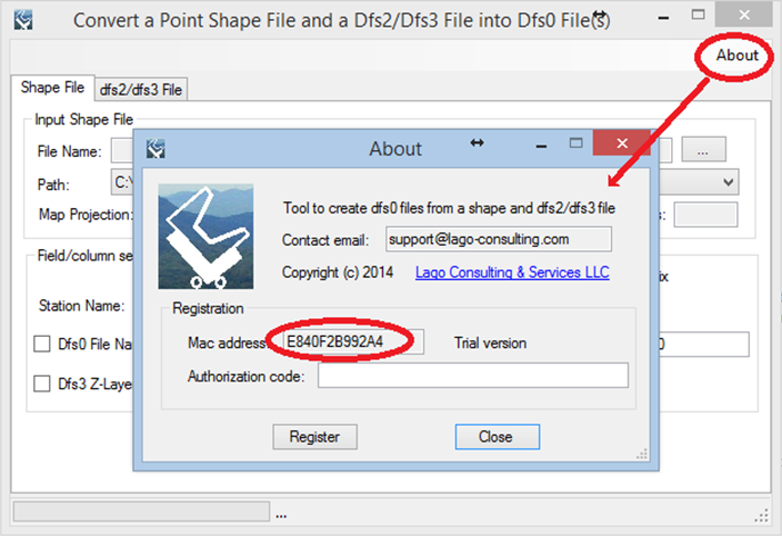
​After these steps, the authorization code will be sent to the email that you provided during the PayPal payment process.

Support
Users can report bugs and send comments by email to support@lago-consulting.com.  
 
Created by Lago Consulting & Services LLC. © 2014. Last updated on 05/28/2019

Questions?
Contact Us

Lago consulting and services understands the customer's risks when downloading  or installing software from internet. The integrity of the software we offer here as well as the legitimacy of our company are ensured by our code signing certificate.
Free version available in the Toolbox or here
​
for an independent download.
Picture
If you are interested on purchasing this tool contact us for more information. ​
Picture
  • Home
  • About Us
    • The Company
    • Leadership
    • Certifications
  • Services
    • Modeling Services
    • Consulting Services
    • Software Development >
      • Fill Sinks Plus
      • HEC-RAS to MIKE11
      • SWMM5 to Shp
      • Lago Toolbox
  • Projects
  • FAQ/Contact
  • LAGO-LG2 JV
Modeling Services
Picture

- Data mining & Processing
- Conceptualization & Setup
- Sensitivity Tests
- Model Calibration
- Model Telescoping
- Design Storm Simulations
- Scenario Evaluations
​- Post-Processing of results
- Peer review
- Model QA/QC
- Mass balance checks
- Fixing numerical instabilities
- Calibration/validation checks
​- Reservoir Storage Modeling
- GIS data mgmt. and tools

Consulting Areas
Picture

- Natural resources planning
- Stormwater management
- Groundwater management
- Surface water structure design
- Water supply planning
- Species and sediment transport
- Salt water intrusion
- Floodplain delineation & management
- Floodway Encroachment Analysis
​- Urban and coastal flooding
- Water quality studies
- Wetland conservation and restoration
- Wellhead protection area delineation
- Landscape ecology
- Water regulations permitting

Featured Software
Picture

MIKE 11
MIKE SHE
MIKE21
ECOLab
MODFLOW
GWV (Vistas)
MODHMS
​GIS-ArcMap

HEC-RAS
​HEC-HMS
EPA-SWMM
​XP-SWMM
ICPR
​RiverFlow2D
WASP
HSPF

Software Development
Picture

Spreadsheet modeling
File format converters
Pre- & post-processing tools
A la carte software (C#, Python, etc)


Employee Login   ​
         About    |    Terms  and Conditions    |    Privacy Policy    |    Certifications    | ​   Tools    |    Contact us     
Picture
4237 Henderson Blvd #201, Tampa FL 33629.   |   P.O. Box 10481, Tampa, FL, 33679   |   813-774-5559
www.lago-consulting.com & Lago Consulting & Services LLC.    © 2023  All Rights Reserved