LAGO   Consulting   &   Services LLC
    • Home
    • About Us
      • The Company
      • Leadership
      • Certifications
    • Services
      • Modeling Services
      • Consulting Services
      • Software Development >
        • Fill Sinks Plus
        • HEC-RAS to MIKE11
        • SWMM5 to Shp
        • Lago Toolbox
    • Projects
    • FAQ/Contact
    • LAGO-LG2 JV
  • MENU

Shape plus dfs0 to dfs2

Purpose
    This tool allows the conversion of a point shape file and a set of dfs0 files into a time-varying dfs2 file. Some highlights are:
  • Shape fields or columns can be used to specify the dfs0 file names, their paths, and/or their item numbers. 
  • The option of using the constant values of a field or column is also included. 
  • Output dsf2 grid can be customized or adopted from an existing dfs2 file.
  • Optional gap filling of the dfs0 time series by linear interpolation and by Julian Day running average. Values are assumed instantaneous.
  • Spatial interpolation by using nearest neighbor, triangular-based, inverse squared distance (traditional and directional), or simple kriging  methods.
  • Output dfs2 time scale can be customized independently from time scale in the dfs0 files.
  • Optional MIKE SHE style html files with time series plots comparing original, time-interpolated, and spatial-interpolated values for verification purposes.
The Directional Inverse Squared Distance Method is a two-step method that divides the space in 8 directions. The traditional Inverse Squared Distance Method is applied first in each direction, and then applied to the results in those directions.
​
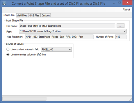
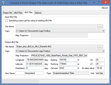
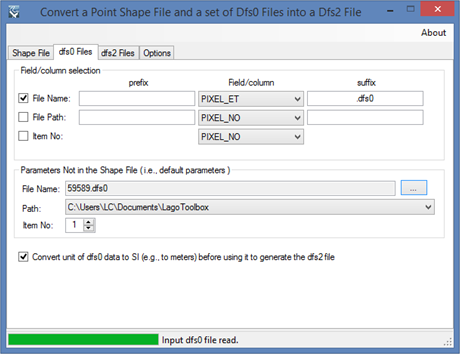
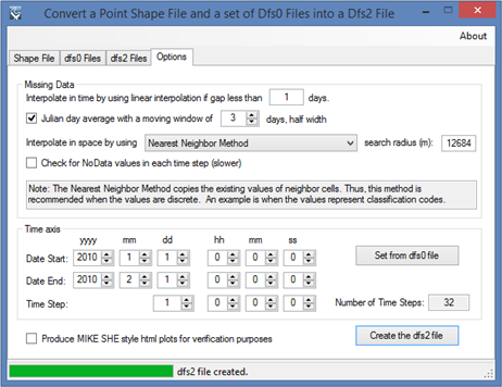
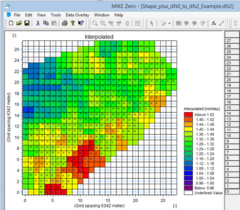
​Usage
    The user must specify a point shape file as input and choose between using constant values in a field or using time-series values in the dfs0 files. In the second case, the user must specify the fields corresponding to the dfs0 file names, paths, and/or item numbers; as well as enter a dfs0 file used by default. The output dfs2 grid can be customized or adopted from an existing dfs2 file. Finally, the user must select the interpolation options and customize the output dfs2 time axis.
    The free version allows the user to save up to the first 50x50 elements of the grid.

Pre-requisites
    It requires MIKE ZERO 2012, 2014, 2016, 2017 or 2019 to be installed, but the DHI license is not necessary.
    MIKE SHE style html plots generated for verification purposes require 32-bit internet browsers.

Example of use
    The screens shown below illustrate the processing of the shape file “Shape_plus_dfs0_to_dfs2_Example.shp” provided with the installation of MIKE ZERO. The set dfs0 files were obtained after using the provided list of pixel IDs (Example_of_ListPixelIDs.txt) in the tool “GOES USGS Download”, and generating the corresponding dfs0 files with the tool “GOES USGS ET to dfs0”.
​
Picture
Picture
Picture
Picture
Picture

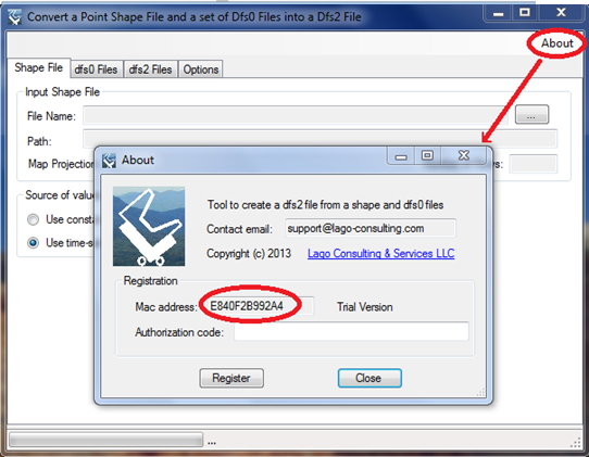
​Registration
    In order to have full functionality of this tool, the user needs to complete the registration by following these steps:
​Go to the right-top corner in this tool, click on the “About” button, and copy the Mac address shown there.
Picture
In the tool’s webpage, use the box above the "Add to Cart" button to enter the Mac address. Then, click on the "Add to Cart" button right below to enter your payment information.
​After these steps, the authorization code will be sent to the email that you provided during the PayPal payment process.

Support
Users can report bugs and send comments by email to [email protected].  
 
Created by Lago Consulting & Services LLC. © 2014. Last updated on 06/25/2020

Questions?
Contact Us

Lago consulting and services understands the customer's risks when downloading  or installing software from internet. The integrity of the software we offer here as well as the legitimacy of our company are ensured by our code signing certificate.
Free version available in the Toolbox or here
​
for an independent download.
Picture
If you are interested on purchasing this tool contact us for more information. ​
Picture
  • Home
  • About Us
    • The Company
    • Leadership
    • Certifications
  • Services
    • Modeling Services
    • Consulting Services
    • Software Development >
      • Fill Sinks Plus
      • HEC-RAS to MIKE11
      • SWMM5 to Shp
      • Lago Toolbox
  • Projects
  • FAQ/Contact
  • LAGO-LG2 JV
Modeling Services
Picture

- Data mining & Processing
- Conceptualization & Setup
- Sensitivity Tests
- Model Calibration
- Model Telescoping
- Design Storm Simulations
- Scenario Evaluations
​- Post-Processing of results
- Peer review
- Model QA/QC
- Mass balance checks
- Fixing numerical instabilities
- Calibration/validation checks
​- Reservoir Storage Modeling
- GIS data mgmt. and tools

Consulting Areas
Picture

- Natural resources planning
- Stormwater management
- Groundwater management
- Surface water structure design
- Water supply planning
- Species and sediment transport
- Salt water intrusion
- Floodplain delineation & management
- Floodway Encroachment Analysis
​- Urban and coastal flooding
- Water quality studies
- Wetland conservation and restoration
- Wellhead protection area delineation
- Landscape ecology
- Water regulations permitting

Featured Software
Picture

MIKE 11
MIKE SHE
MIKE21
ECOLab
MODFLOW
GWV (Vistas)
MODHMS
​GIS-ArcMap

HEC-RAS
​HEC-HMS
EPA-SWMM
​XP-SWMM
ICPR
​RiverFlow2D
WASP
HSPF

Software Development
Picture

Spreadsheet modeling
File format converters
Pre- & post-processing tools
A la carte software (C#, Python, etc)


Employee Login   ​
         About    |    Terms  and Conditions    |    Privacy Policy    |    Certifications    | ​   Tools    |    Contact us     
Picture
4921 S West Shore Tampa FL 33611, P.O. Box 10481, Tampa, FL 33679.  813-774-5559
www.lago-consulting.com & Lago Consulting & Services LLC.    © 2023  All Rights Reserved