LAGO   Consulting   &   Services LLC
    • Home
    • About Us
      • The Company
      • Leadership
      • Certifications
    • Services
      • Modeling Services
      • Consulting Services
      • Software Development >
        • Fill Sinks Plus
        • HEC-RAS to MIKE11
        • SWMM5 to Shp
        • Lago Toolbox
    • Projects
    • FAQ/Contact
    • LAGO-LG2 JV
  • MENU
Picture
Picture

Hydraulic & Hydrology based permiting

LAGO performs hydrology/hydraulic analysis for flood control related projects. LAGO works with experts in local, state and federal regulations related to design and construction of water, wastewater, and reclaimed water systems and facilities, and we understand the complex issues involved in water regulations and conservation. In LAGO, we do professional engineering assessments, studies, analysis and models of systems and facilities to support planning, expansion, rationalizing and decommissioning projects of our clients.  We correlate and integrate the permitting process with geographic information system and hydraulic-hydrologic analysis. We develop, analyze and use computer models to provide our clients with the reasonable assurances involved in the permitting protocol.


contact us: 813.774.5559

Picture
Our permitting consulting/services include:
Surface Water / Groundwater Use related Permits 
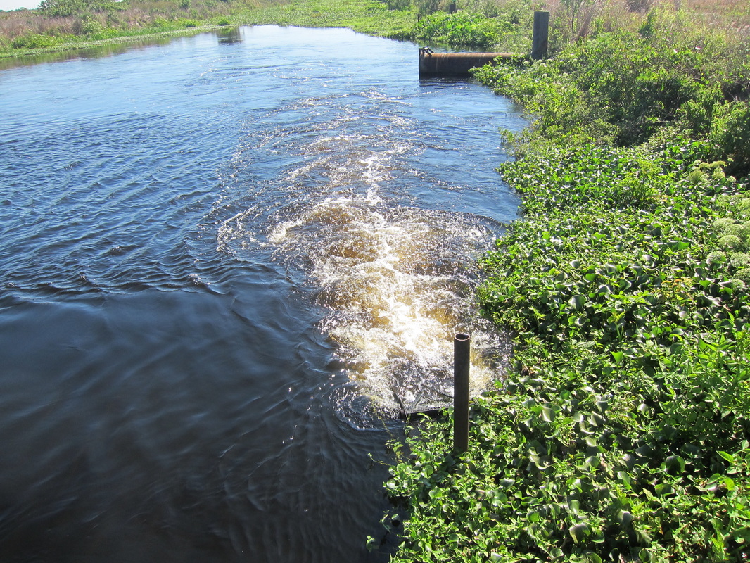
This is a permitting system for surface and groundwater withdrawals in Florida. In order to obtain a Water Use Permit (WUP), an Applicant must demonstrate that the water use is reasonable and beneficial, is in the public interest, and will not interfere with any existing legal use of water, by providing reasonable assurances, on both an individual and a cumulative basis. It should be demostrated that the water use will
​      -  be necessary to fulfill a certain reasonable demand,
      -  not cause quantity or quality changes that adversely impact water
          resources, including both surface and ground water,

      -  not cause adverse environmental impact to wetlands, lakes, streams,
​          estuaries, fish and wildlife or other natural resources,
      -  not interfere with a reservation of water as set forth in Rule 40D-2.302
      -  not significantly induce saline water intrusion,
      -  not cause pollution of the aquifer,
      -  incorporate water conservation measures,

among others evaluation criteria, as stated in the rules of the corresponding water management district. 
​Rules regarding the trigger levels for permits and the degree of reporting of water use data vary from one district to another, with criteria being more stringent in critical water use areas. Usually, permits are required for all users having the capacity to use 1,000,000 gpd, and for wells greater than six inches in diameter.
Picture
Some projects also require an Environmental Resource Permit (ERP) before a WUP will be issued. 
Environmental Resources related Permits
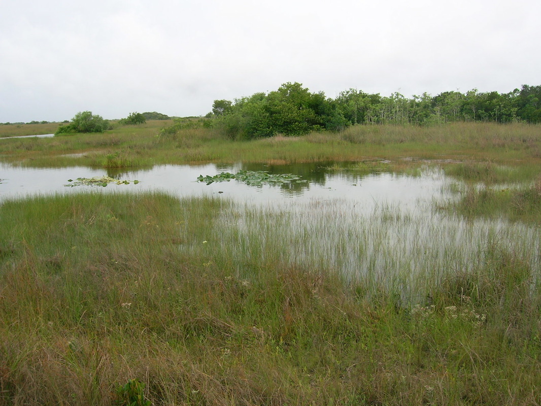
The Environmental Resource Permitting (ERP) Program regulates activities involving the alteration of surface water flows  in order to prevent flooding and protect water quality of lakes, streams, wetlands and and other surface water bodies. ERP applications are processed by either the Department of Environmental Protection or one of the state's water management districts, in accordance with the corresponding division of responsibilities. The ERP is required for activities such as:
      -  Dredging and/or filling in wetlands or surface water bodies/areas
      -  Use of sovereign submerged lands
 
      -  Constructing Flood Protection Facilities
      -  Activities in uplands which may disturb the stormwater runoff 
      -  Site Grading

      -  Building dams or reservoirs
      -  Other activities affecting the water bodies
   
​

Any construction site that will result in a disturbance of one acre or more of upland or wetland is required to seek coverage under the Generic Permit for Stormwater Discharge from Large and Small Construction Activities or NPDES Permit (National Pollution Discharge Elimination System). The NPDES stormwater permitting program is separate from the State's stormwater/environmental resource permitting programs
Picture
The type of permit or exemption that is required depends on what and where you want to build or develop. 
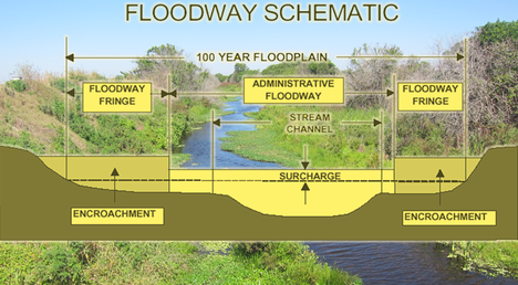
Floodplain and Floodway Encroachment related Permits
All proposed development in the floodplain must meet the "no adverse affect" (any physical damage to an adjoining or other property) criteria, while proposed development in the floodway must also meet the "no-rise" criteria. In many cases, the 100-year floodplain has been divided into two zones, the floodway and the floodway fringe. The floodway is that area that must be kept open to convey flood waters downstream, while the floodway fringe is that area that can be developed in accordance with FEMA standards and the local law. The standards for a floodplain encroachment depend on both the project location and the information provided on flood hazard maps. Four typical cases are listed below.
   -  Floodplain fringe. If the model used to delimitate
       the floodway boundaries indicated that any
       encroachment in the fringe area would result in a
       “significant” increase in flood levels, then further
       encroachment analysis is required. Usually, it is 
       required to conduct a proper hydraulic analysis using
       an 
effective Hydraulic model as a definitive and
​       defensible analysis.

   -  Floodway. No new development is permitted unless
       it is demonstrated that the proposed encroachment
       will produce no-rise in the 100-year flood elevation.  
   
-  Riverine floodplain with base flood elevations,
       but no floodway. If the flood hazard map designates
       base flood elevations but no floodway is delineated, it
       must be demonstrated that the cumulative effect of the
       proposed development, with all other anticipated
       floodplain development, would not increase the water
       surface elevation of the 100-year flood more than one
       foot (or local standard) at any location. 

   -  Approximate A Zones.  If the floodplain boundaries
       were established using approximate techniques (which
       produce neither floodways nor base flood elevations),
       then the authority may require an analysis to
       demonstrate that the proposed development would
       not result in physical damage to any other property.
Picture
The requirement of "no-rise" certification for proposed development in the floodway rests on the Code of Federal Regulations 44 CFR Part 60.3(d)(3). "No-rise" is defined as a 0.00-feet difference in the computed Base Flood Elevation (BFE)'s at each modeled cross-section. This is normally demonstrated by comparing the BFE in the model outputs of the Pre-development and Post-development runs.
While the "No-rise criteria" is a must, a detailed engineering analysis to prove "No Adverse Effects"  is not required for all developments within the floodway fringe. It may be required for larger projects that can potentially result in physical damage to other properties.

To request our service click HERE

  • Home
  • About Us
    • The Company
    • Leadership
    • Certifications
  • Services
    • Modeling Services
    • Consulting Services
    • Software Development >
      • Fill Sinks Plus
      • HEC-RAS to MIKE11
      • SWMM5 to Shp
      • Lago Toolbox
  • Projects
  • FAQ/Contact
  • LAGO-LG2 JV
Modeling Services
Picture

- Data mining & Processing
- Conceptualization & Setup
- Sensitivity Tests
- Model Calibration
- Model Telescoping
- Design Storm Simulations
- Scenario Evaluations
​- Post-Processing of results
- Peer review
- Model QA/QC
- Mass balance checks
- Fixing numerical instabilities
- Calibration/validation checks
​- Reservoir Storage Modeling
- GIS data mgmt. and tools

Consulting Areas
Picture

- Natural resources planning
- Stormwater management
- Groundwater management
- Surface water structure design
- Water supply planning
- Species and sediment transport
- Salt water intrusion
- Floodplain delineation & management
- Floodway Encroachment Analysis
​- Urban and coastal flooding
- Water quality studies
- Wetland conservation and restoration
- Wellhead protection area delineation
- Landscape ecology
- Water regulations permitting

Featured Software
Picture

MIKE 11
MIKE SHE
MIKE21
ECOLab
MODFLOW
GWV (Vistas)
MODHMS
​GIS-ArcMap

HEC-RAS
​HEC-HMS
EPA-SWMM
​XP-SWMM
ICPR
​RiverFlow2D
WASP
HSPF

Software Development
Picture

Spreadsheet modeling
File format converters
Pre- & post-processing tools
A la carte software (C#, Python, etc)


Employee Login   ​
         About    |    Terms  and Conditions    |    Privacy Policy    |    Certifications    | ​   Tools    |    Contact us     
Picture
4921 S West Shore Tampa FL 33611, P.O. Box 10481, Tampa, FL 33679.  813-774-5559
www.lago-consulting.com & Lago Consulting & Services LLC.    © 2023  All Rights Reserved