LAGO   Consulting   &   Services LLC
    • Home
    • About Us
      • The Company
      • Leadership
      • Certifications
    • Services
      • Modeling Services
      • Consulting Services
      • Software Development >
        • Fill Sinks Plus
        • HEC-RAS to MIKE11
        • SWMM5 to Shp
        • Lago Toolbox
    • Projects
    • FAQ/Contact
    • LAGO-LG2 JV
  • MENU

Lateral Flows

Purpose
    This tool allows the computation of lateral flow between areas from MIKESHE and MIKE21 model results.  The model results can be specified as:
  1. Surface water flows
  2. Groundwater flows (from MIKESHE)
    In comparison with the tool “MShe_FlowThroughLine .exe” as distributed by DHI, this tool computes the MIKESHE OL and SZ lateral flows among more than two neighbor areas in a user-friendly GUI environment.

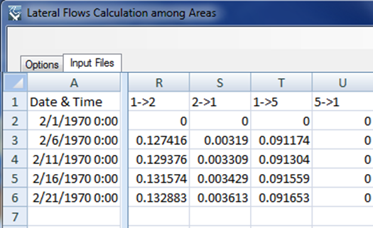
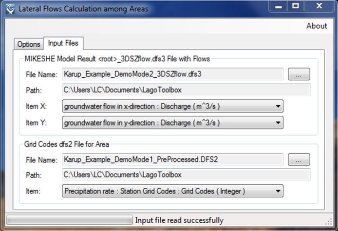
Usage
    The user must select the desired options and enter the necessary grid files. They are the model result dfs2/dfs3 file and the grid code dfs2 file. After that, the user can specify the time period within which to process and compute the lateral flows. The lateral flows between each pair of neighboring grid codes are saved into a comma-separated (csv) file. The option of processing Mike21 results is still in testing, though.
    The free version allows the user to save the lateral flows of the first pair of neighboring grid codes.

Pre-requisites
    It requires MIKE ZERO 2012, 2014, 2016, 2017 or 2019 to be installed, but the DHI license is not necessary.
​
Example of use
    The screens shown below illustrate the processing of the file “Karup_Example_DemoMode2_3DSZflow.dfs3” with grid codes in the file “Karup_Example_DemoMode1_PreProcessed.dfs2”, which are provided with the installation of the Toolbox. 
​
Picture
Picture
Picture
    ​The columns contain only positive flows between grid coded areas. Thus, the total or net flow from code 1 to code 2 is equal to “1->2” minus “2->1”. In the case of working with groundwater flows, the layer numbering convention is that they are numbered from the bottom up, starting with zero. Therefore, in the case of having three SZ layers, “SZ0” correspond to the bottom and “SZ2” to the top layers.
​Registration
    In order to have full functionality of this tool, the user needs to complete the registration by following these steps:
    ​Go to the right-top corner in this tool, click on the “About” button, and copy the Mac address shown there.
Picture
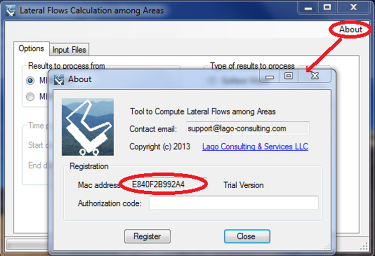
    ​In the tool’s webpage, use the box above the "Add to Cart" button to enter the Mac address. Then, click on the "Add to Cart" button right below to enter your payment information.
    ​After these steps, the authorization code will be sent to the email that you provided during the PayPal payment process.

Support
Users can report bugs and send comments by email to [email protected].  
 
Created by Lago Consulting & Services LLC. © 2014. Last updated on 05/28/2019

Questions?
Contact Us

Lago consulting and services understands the customer's risks when downloading  or installing software from internet. The integrity of the software we offer here as well as the legitimacy of our company are ensured by our code signing certificate.
Free version available in the Toolbox or here
​
for an independent download.
Picture
If you are interested on purchasing this tool contact us for more information. ​
Picture
  • Home
  • About Us
    • The Company
    • Leadership
    • Certifications
  • Services
    • Modeling Services
    • Consulting Services
    • Software Development >
      • Fill Sinks Plus
      • HEC-RAS to MIKE11
      • SWMM5 to Shp
      • Lago Toolbox
  • Projects
  • FAQ/Contact
  • LAGO-LG2 JV
Modeling Services
Picture

- Data mining & Processing
- Conceptualization & Setup
- Sensitivity Tests
- Model Calibration
- Model Telescoping
- Design Storm Simulations
- Scenario Evaluations
​- Post-Processing of results
- Peer review
- Model QA/QC
- Mass balance checks
- Fixing numerical instabilities
- Calibration/validation checks
​- Reservoir Storage Modeling
- GIS data mgmt. and tools

Consulting Areas
Picture

- Natural resources planning
- Stormwater management
- Groundwater management
- Surface water structure design
- Water supply planning
- Species and sediment transport
- Salt water intrusion
- Floodplain delineation & management
- Floodway Encroachment Analysis
​- Urban and coastal flooding
- Water quality studies
- Wetland conservation and restoration
- Wellhead protection area delineation
- Landscape ecology
- Water regulations permitting

Featured Software
Picture

MIKE 11
MIKE SHE
MIKE21
ECOLab
MODFLOW
GWV (Vistas)
MODHMS
​GIS-ArcMap

HEC-RAS
​HEC-HMS
EPA-SWMM
​XP-SWMM
ICPR
​RiverFlow2D
WASP
HSPF

Software Development
Picture

Spreadsheet modeling
File format converters
Pre- & post-processing tools
A la carte software (C#, Python, etc)


Employee Login   ​
         About    |    Terms  and Conditions    |    Privacy Policy    |    Certifications    | ​   Tools    |    Contact us     
Picture
4921 S West Shore Tampa FL 33611, P.O. Box 10481, Tampa, FL 33679.  813-774-5559
www.lago-consulting.com & Lago Consulting & Services LLC.    © 2023  All Rights Reserved