LAGO   Consulting   &   Services LLC
    • Home
    • About Us
      • The Company
      • Leadership
      • Certifications
    • Services
      • Modeling Services
      • Consulting Services
      • Software Development >
        • Fill Sinks Plus
        • HEC-RAS to MIKE11
        • SWMM5 to Shp
        • Lago Toolbox
    • Projects
    • FAQ/Contact
    • LAGO-LG2 JV
  • MENU

Hydroperiod from Microtopography

Purpose
    This tool allows the computation of hydroperiod and water depth maps at a higher resolution from MIKE SHE and MIKE 21 model results. The model results used as input can be specified as:
  1. Surface water depth
  2. Surface water level
  3. Head of top SZ layer (from MIKE SHE). 
  4. Depth to Phreatic Surface (from MIKE SHE)
    The last two options may be preferable since the ground water head and phreatic surface outputs keep track of the water table variations even at zero surface water depth in the coarser resolution. The depth to phreatic surface option may be a better choice if the water table goes below the bottom of the top layer.
    The time period to process the model results can be customized to a shorter date period or to a Julian Day interval. The last option allows finding seasonal average magnitudes.


Usage
    The user must select the desired options and enter the necessary grid files. They are the model result dfs2/dfs3 file and the higher-resolution topography file. After that, the user can specify the time period through which to process and compute the outputs. Please be aware that in dependence with the output resolution and the number of time steps to process, the tool could take up to several hours to complete the calculations.
    This tool computes the water depth at the finer resolution for each time step by using a bilinear interpolation. The topography elevation could be in different units (i.e. feet instead of meters) and in a different geographical projection and grid rotation with respect to the model result files. A shorter processing period or a Julian Day interval could be specified.  After processing all the time steps of interest, the tool can provide the following outputs:
  1. Hydroperiod fraction or relative number of time steps with inundation. This is in the scale from zero to one showing whether water is never or always ponded, respectively.
  2. Mean water level.
  3. Mean water depth, which includes zero water depth values in the average.
  4. Mean water depth during hydroperiod, which excludes zero water depth values. This output may be as important as the hydroperiod in a wetland. 
  5. Maximum water depth. This output may be important in flooding studies. 
  6. Maximum number of consecutive time steps with water above a specified level. In this case, the specified level could be positive but also negative (i.e. below the ground in reference to the higher-resolution topography). The former case may give you maps with the duration of the flooding, while the second case (combined with the Head of top SZ layer from MIKE SHE) may give you a maps with the duration of the excess in a given soil saturation.
    The free version allows the user to save the first 50x50 elements of the model grid.

Pre-requisites
    It requires MIKE ZERO 2012, 2014, 2016, 2017 or 2019 to be installed, but the DHI license is not necessary.

Example of use
    The screens shown below illustrate the processing of the file “Karup_Example_DemoMode1_3DSZflow.dfs3” by using the same resolution topography as in the file “Karup_Example_DemoMode1_PreProcessed.dfs2”, which are provided in the installation of the Toolbox.
Picture
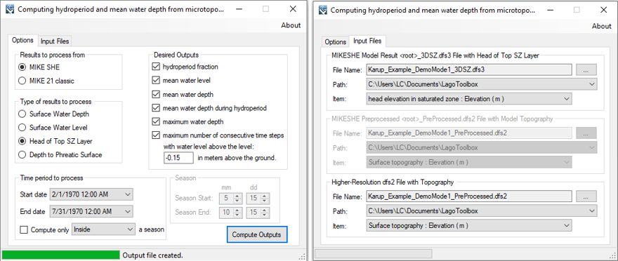
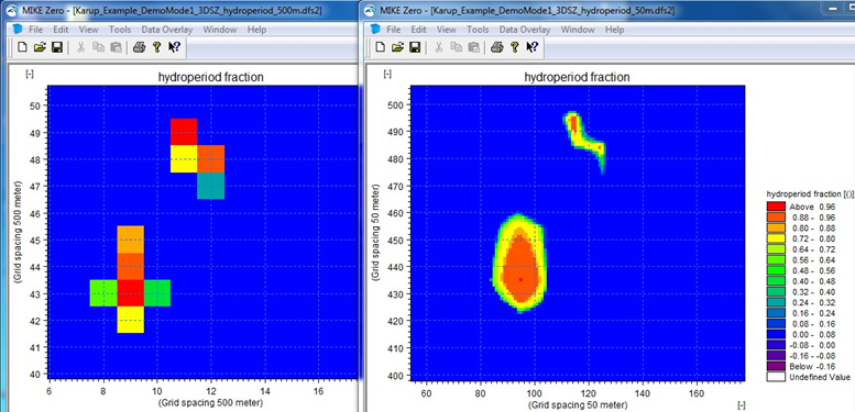
    ​The following screen compares the hydroperiod at the model resolution and at a higher resolution obtained from this tool. In the second case, the 10-times higher resolution topography was obtained simply from the preprocessed topography by using the bilinear interpolation method in the tool “resample dfs2 file”. 
Picture

​Registration
    In order to have full functionality of this tool, the user needs to complete the registration by following these steps:
    ​Go to the right-top corner in this tool, click on the “About” button, and copy the Mac address shown there.
Picture
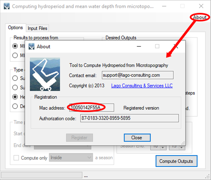
    In the tool’s webpage, use the box above the "Add to Cart" button to enter the Mac address. Then, click on the "Add to Cart" button right below to enter your payment information.
    ​After these steps, the authorization code will be sent to the email that you provided during the PayPal payment process.

Support
Users can report bugs and send comments by email to support@lago-consulting.com. 
 
Created by Lago Consulting & Services LLC. © 2014. Last updated on 11/25/2019

Questions?
Contact Us

Lago consulting and services understands the customer's risks when downloading  or installing software from internet. The integrity of the software we offer here as well as the legitimacy of our company are ensured by our code signing certificate.
Free version available in the Toolbox or here
​
for an independent download.
Picture
If you are interested on purchasing this tool contact us for more information. 
Picture
  • Home
  • About Us
    • The Company
    • Leadership
    • Certifications
  • Services
    • Modeling Services
    • Consulting Services
    • Software Development >
      • Fill Sinks Plus
      • HEC-RAS to MIKE11
      • SWMM5 to Shp
      • Lago Toolbox
  • Projects
  • FAQ/Contact
  • LAGO-LG2 JV
Modeling Services
Picture

- Data mining & Processing
- Conceptualization & Setup
- Sensitivity Tests
- Model Calibration
- Model Telescoping
- Design Storm Simulations
- Scenario Evaluations
​- Post-Processing of results
- Peer review
- Model QA/QC
- Mass balance checks
- Fixing numerical instabilities
- Calibration/validation checks
​- Reservoir Storage Modeling
- GIS data mgmt. and tools

Consulting Areas
Picture

- Natural resources planning
- Stormwater management
- Groundwater management
- Surface water structure design
- Water supply planning
- Species and sediment transport
- Salt water intrusion
- Floodplain delineation & management
- Floodway Encroachment Analysis
​- Urban and coastal flooding
- Water quality studies
- Wetland conservation and restoration
- Wellhead protection area delineation
- Landscape ecology
- Water regulations permitting

Featured Software
Picture

MIKE 11
MIKE SHE
MIKE21
ECOLab
MODFLOW
GWV (Vistas)
MODHMS
​GIS-ArcMap

HEC-RAS
​HEC-HMS
EPA-SWMM
​XP-SWMM
ICPR
​RiverFlow2D
WASP
HSPF

Software Development
Picture

Spreadsheet modeling
File format converters
Pre- & post-processing tools
A la carte software (C#, Python, etc)


Employee Login   ​
         About    |    Terms  and Conditions    |    Privacy Policy    |    Certifications    | ​   Tools    |    Contact us     
Picture
4237 Henderson Blvd #201, Tampa FL 33629.   |   P.O. Box 10481, Tampa, FL, 33679   |   813-774-5559
www.lago-consulting.com & Lago Consulting & Services LLC.    © 2023  All Rights Reserved