LAGO   Consulting   &   Services LLC
    • Home
    • About Us
      • The Company
      • Leadership
      • Certifications
    • Services
      • Modeling Services
      • Consulting Services
      • Software Development >
        • Fill Sinks Plus
        • HEC-RAS to MIKE11
        • SWMM5 to Shp
        • Lago Toolbox
    • Projects
    • FAQ/Contact
    • LAGO-LG2 JV
  • MENU

Extend dfs2 Files

Purpose
    
This tool allows the extension of the period of a dfs2 file by:
  1. Periodically copying an existing data period, or
  2. Using Julian Day running average values
    The tool also allows interpolation over time to remove missing (no data) values.

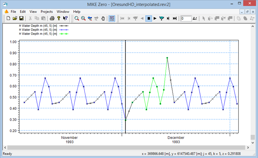
Usage
    The user must specify the dfs2 file name and the existing data period to be used for the extrapolation. By default, the data is repeated periodically before or after the existing data period in accordance with the desired output period specified by the user.
    The user also has the options of a) leaving only the selected input data in the output file, b) using Julian Day running average values if the data period is longer than one year, and c) conducting linear interpolation over time in order to remove missing (no data) values. The size of the output files can be reduced optionally by skipping every a chosen number of time steps.
    Clicking the “Extend dfs2 file” button produces up to 3 new dfs2 files: a file with the Julian Day average values, a file with the extended data, and a file after the linear interpolation is conducted. All those files cover the desired output period.  
    The free version allows the user to save up to the first 50x50 elements of the grid.
​
Pre-requisites
    It requires MIKE ZERO 2012, 2014, 2016, 2017 or 2019 to be installed, but the DHI license is not necessary.

Example of use
    The two screens shown below illustrate the processing of the file “OresundHD.dfs2” as provided from the installation of MIKE ZERO. In this case, ten time steps of the data are repeated periodically to cover a two-month period. A result viewer (.rev) file was created to show the time series values in the pixel (45,5) for the original (green), the extended (blue), and the interpolated (black) dfs2 files.​
​
Picture
Picture

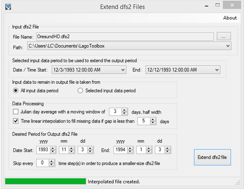
Registration
    In order to have full functionality of this tool, the user needs to complete the registration process by following these steps:
​Go to the right-top corner in this tool, click on the “About” button, and copy the Mac address shown there.
Picture
In the tool’s webpage, use the box above the "Add to Cart" button to enter the Mac address. Then, click on the "Add to Cart" button right below to enter your payment information.
​After these steps, the authorization code will be sent to the email that you provided during the PayPal payment process.

Support
Users can report bugs and send comments by email to [email protected].  
 
Created by Lago Consulting & Services LLC. © 2014. Last updated on 05/28/2019

Questions?
Contact Us

Lago consulting and services understands the customer's risks when downloading  or installing software from internet. The integrity of the software we offer here as well as the legitimacy of our company are ensured by our code signing certificate.
Free version available in the Toolbox or here
​
for an independent download.
Picture
If you are interested on purchasing this tool contact us for more information. ​
Picture
  • Home
  • About Us
    • The Company
    • Leadership
    • Certifications
  • Services
    • Modeling Services
    • Consulting Services
    • Software Development >
      • Fill Sinks Plus
      • HEC-RAS to MIKE11
      • SWMM5 to Shp
      • Lago Toolbox
  • Projects
  • FAQ/Contact
  • LAGO-LG2 JV
Modeling Services
Picture

- Data mining & Processing
- Conceptualization & Setup
- Sensitivity Tests
- Model Calibration
- Model Telescoping
- Design Storm Simulations
- Scenario Evaluations
​- Post-Processing of results
- Peer review
- Model QA/QC
- Mass balance checks
- Fixing numerical instabilities
- Calibration/validation checks
​- Reservoir Storage Modeling
- GIS data mgmt. and tools

Consulting Areas
Picture

- Natural resources planning
- Stormwater management
- Groundwater management
- Surface water structure design
- Water supply planning
- Species and sediment transport
- Salt water intrusion
- Floodplain delineation & management
- Floodway Encroachment Analysis
​- Urban and coastal flooding
- Water quality studies
- Wetland conservation and restoration
- Wellhead protection area delineation
- Landscape ecology
- Water regulations permitting

Featured Software
Picture

MIKE 11
MIKE SHE
MIKE21
ECOLab
MODFLOW
GWV (Vistas)
MODHMS
​GIS-ArcMap

HEC-RAS
​HEC-HMS
EPA-SWMM
​XP-SWMM
ICPR
​RiverFlow2D
WASP
HSPF

Software Development
Picture

Spreadsheet modeling
File format converters
Pre- & post-processing tools
A la carte software (C#, Python, etc)


Employee Login   ​
         About    |    Terms  and Conditions    |    Privacy Policy    |    Certifications    | ​   Tools    |    Contact us     
Picture
4921 S West Shore Tampa FL 33611, P.O. Box 10481, Tampa, FL 33679.  813-774-5559
www.lago-consulting.com & Lago Consulting & Services LLC.    © 2023  All Rights Reserved